Jaalinalso Ja'aliyin, Jaaliyin, Gaalin
The Nile Valley from Khartoum north through Shendi, Metemma, Berber and Atbara to the Fifth Cataract · Sudanese Arabic · Sudan's last census, in 2008, dropped ethnicity and religion from the questionnaire entirely for political reasons and gives no breakdown by group. Independent people-group estimates put the Jaalin at around 2.9 million, but that is a demographic projection rather than a count.
The Jaalin trace descent from Abbas, an uncle of the Prophet Muhammad, a genealogy central to their self-image as one of Sudan's founding Arab riverine tribes. Historically merchants, administrators and Nile traders, they have supplied a disproportionate share of Khartoum's political and military elite since independence. The Khatmiyya and Majdhubiyya Sufi orders run deep here, shaping both religious practice and political loyalty. Riverine life centres on date palm cultivation and Nile-side agriculture. Weddings involve multi-night henna ceremonies with drumming and call-and-response song, and genealogical recitation at family gatherings remains a living oral tradition rather than a museum piece.
Visiting: Dress modestly, accept the tea or coffee offered on arrival, and greet the eldest person present first. Ask before photographing women, and respect fasting hours during Ramadan even if you are not fasting yourself.
Shaigiyaalso Shaiqiya, Shaigia, Shaikia
The Nile Valley between Korti and the Fourth Cataract, and the Bayuda Desert fringe near Merowe · Sudanese Arabic · No ethnic data exists in the 2008 census. An independent people-group estimate puts the Shaigiya at around 845,000, a figure to be read as an outside projection rather than an official count.
Renowned as horsemen who resisted the Turco-Egyptian conquest in the 1820s, the Shaigiya built a military reputation that carried into the modern Sudanese army, and several of Sudan's post-independence heads of state have claimed Shaigiya descent, a fact often invoked in Sudanese political commentary. Riverine agriculture, dates and wheat grown on Nile terraces, has been central to livelihood for generations, but the Merowe Dam, completed in 2009, flooded stretches of that terrace land and forced resettlement. Tribal poetry and praise-song tied to military history are still performed at gatherings.
Visiting: Standard Nile-valley hospitality norms apply. Raise the Merowe Dam resettlement only if you are invited to, since for families relocated to desert schemes it remains an unresolved grievance rather than settled history.
Danaglaalso Dongolawi, Dongola Nubians, Danagala
The Nile Valley around Old Dongola, between the Third Cataract and al-Dabba · Andaandi, Sudanese Arabic · No current official figure exists, since the 2008 census recorded no ethnicity at all. Older Danagla are still counted among the Nile Nubian speakers of Andaandi, but no reliable separate headcount exists now that Arabic has become the majority home language.
The Danagla hold a genuinely contested dual identity, since many assert descent from the Ja'aliyin Arab confederation while the oldest generation still speaks Andaandi, the Dongolawi Nubian language, at home. Historically they ran long-distance caravan trade across the Sahara toward West Africa. Mudbrick house architecture with vaulted roofs and internal courtyards distinguishes Danagla villages from purely Arab riverine settlements, and date farming remains the backbone of the local economy.
Visiting: Do not assume a Danagla family identifies simply as Arab or simply as Nubian without asking, since the shift from Andaandi to Arabic across generations is a live and sometimes sensitive family subject rather than a closed question.
Baggaraalso Cattle Arabs; constituent tribes include the Rizeigat, Messiria, Habbaniya, Ta'aisha, Beni Halba and Hawazma
The savanna belt of southern Kordofan and southern Darfur, with seasonal grazing migration toward the South Sudan border · Sudanese Arabic · The 2008 census has no ethnicity field. Aggregate figures cited in ethnographic sources put the wider Baggara confederation at roughly 6 million across the Sahel, with over 3.7 million in Sudan specifically. These are compiled estimates rather than census counts.
Cattle-based transhumant pastoralism defines Baggara life, with seasonal migration moving herds between wet-season pastures in Kordofan and Darfur and dry-season grazing nearer the rivers, and a horse and camel-mounted warrior tradition runs deep. That history has to be stated alongside a harder fact: specific Baggara lineages, above all the Mahariya branch of the Rizeigat, were armed by the government from 2003 as the core of the Janjaweed militias used against Fur, Masalit and Zaghawa communities in Darfur, and the same leadership later built the Rapid Support Forces. That is a documented history of particular clans and a state recruitment policy rather than a description of the Baggara as a whole, the great majority of whom are pastoralists with no role in either militia.
Visiting: Do not treat Janjaweed or RSF association as a blanket assumption about any Baggara person you meet, since most have no connection to either. Fresh milk offered to a guest is a serious hospitality gesture and should be accepted. Ask before approaching cattle camps.
Nubiansalso Nile Nubians, Fadicca, Kenzi, Mattoki; distinct from the unrelated Nuba Mountains peoples of South Kordofan
Far northern Sudan along the Nile from Wadi Halfa south to around the Dal Cataract, plus the resettlement towns of Khashm el-Girba and New Halfa in the east · Nobiin, Andaandi, Kenzi · Sudan's 1956 census, the last to count ethnicity in this region with any granularity, recorded 167,831 Nubians. Later independent estimates put Sudanese Nile Nubians anywhere from several hundred thousand to over a million depending on whether Arabised Danagla are included, and the 2008 census recorded no ethnicity data whatsoever.
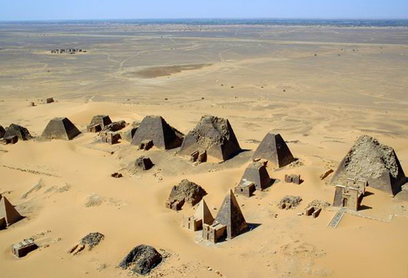
Nubian identity descends from the ancient kingdoms of Kush, Napata and Meroe, the medieval Christian kingdoms of Nobatia, Makuria and Alodia, and the Islamic Nubian sultanates that followed. Houses are brightly painted mudbrick with vaulted roofs and distinctive courtyard entrances. Folklore retains older Nile-based beliefs, including crocodile and river-spirit traditions, layered under Islamic and Sufi practice, and Nubian women have historically held stronger inheritance and household authority than in neighbouring Arab riverine society. Nubians were displaced twice by state infrastructure: the completion of Egypt's Aswan High Dam in 1964 flooded Wadi Halfa and dozens of villages under Lake Nasser, moving more than 50,000 Sudanese Nubians to the semi-arid Khashm el-Girba scheme, and the completion of the Merowe Dam in 2009 flooded the Fourth Cataract region, displacing over 70,000 people, mostly Manasir and Nubian communities, some of whom still dispute the compensation and resettlement terms.
Visiting: Treat dam displacement as an active and unresolved grievance rather than closed history. Ask permission before photographing archaeological sites near Nubian villages, since several are regarded as ancestral rather than purely touristic. Accept tea when it is offered, because Nubian hospitality toward strangers is notably open.
Bejaalso Bedawiyet speakers; constituent clans include the Hadendoa, Bisharin, Amarar, Beni Amer and Ababda
The Red Sea Hills and eastern desert, from the Egyptian border through Red Sea State and Kassala State to the Eritrean border · Bedawiyet · The 2008 census recorded no ethnicity data. Minority Rights Group estimates the Beja at roughly 2 to 3 million, with about 2.6 million placed inside Sudan specifically, and figures in wider circulation range as high as 4 million. These are advocacy and demographic estimates rather than an official count.
The Beja are documented in Pharaonic and classical sources as one of the region's oldest continuously present desert peoples. Hadendoa men traditionally wear a distinctive large hairstyle, the thayeb, which nineteenth-century British colonial troops mockingly nicknamed after fighting Hadendoa cavalry alongside the Mahdist forces. Camel and goat pastoralism remains central to livelihood across the Red Sea Hills, and clan-based customary law continues to settle disputes alongside, and sometimes instead of, the state courts. Eastern Sudan has been politically and economically marginalised from Khartoum since independence, with fewer ministers, less infrastructure and little revenue-sharing from Red Sea State's port and mineral wealth, a grievance that produced the Beja Congress in 1957 and later armed movements.
Visiting: Marginalisation here is a live political grievance rather than a historical footnote, and the mocking colonial nickname for Hadendoa hair should not be repeated even in jest. Ask before photographing hairstyles or the ceremonial daggers, since neither is a prop.
Rashaidaalso Rashaayda
The coastal plain around Kassala and the Red Sea coast between Port Sudan and Suakin, extending into Eritrea · Hejazi Arabic · No 2008 census figure exists. Cited estimates put the Rashaida at about 68,000 in Sudan and around 187,500 in Eritrea, drawn from people-group data rather than from a government count.
Unlike Sudan's older Arab riverine tribes, the Rashaida are recent arrivals, descending from Bani Abs tribespeople who left the Hejaz and Najd around 1846 amid conflict on the Arabian Peninsula. They retain a distinct Bedouin identity centred on camel breeding and trade, and speak a Hejazi-influenced Arabic audibly different from Sudanese Arabic. Women wear a distinctive metallic-embroidered face covering found nowhere else in Sudan, and marriage negotiations traditionally set bride price in camels. Media coverage has at times linked the community to cross-border smuggling on the Sudan and Eritrea corridor, a characterisation the community itself rejects as an unfair generalisation.
Visiting: Photographing Rashaida women, and the face covering in particular, requires explicit permission and is often declined. The community keeps more social distance from outsiders than most Sudanese groups, so do not press for access to camps or gatherings.
Furalso For, Konjara, Fordunga
The Jebel Marra massif and the surrounding plains of central Darfur · Fur · The 2008 census recorded no ethnicity data. Ethnographic tracking cites about 502,000 Fur in Sudan in 1983 rising to roughly 894,000 by 2017, figures compiled from survey and demographic projection rather than from a national count.
The Fur gave Darfur its name, meaning the land of the Fur, and founded the Keira Sultanate, an independent Islamic sultanate that ruled the region from around 1650 until the Anglo-Egyptian conquest in 1916, and the sultanate remains a reference point for political legitimacy in Darfur today. Jebel Marra's volcanic soil supports terraced hillside farming, unusual for the region, growing sorghum, onions and fruit. Since 2003 the Fur have been one of three groups, alongside the Masalit and Zaghawa, targeted in a campaign of killing, rape and village destruction carried out by government forces and allied Janjaweed militia. The United States government determined in 2004 that the campaign met the legal definition of genocide, and the International Criminal Court has pursued charges since the UN Security Council referral of March 2005, including an arrest warrant issued in 2009 against former president Omar al-Bashir on genocide-related counts.
Visiting: Jebel Marra remains conflict-affected with periodic militia presence and landmine risk in places, so independent travel there is not advisable without current and specific security guidance. Do not raise the genocide finding unprompted, and let residents set the terms if the subject comes up.
Zaghawaalso Beri, which is the self-name; also written Zakhawa
North Darfur around Kornoi, Um Baro and Tine, straddling the border into Wadi Fira and Ennedi in Chad · Zaghawa · No figure exists in the 2008 census. Cited estimates put the Zaghawa at around 384,000, with roughly 447,000 native speakers of the language, split mainly between Sudan and Chad. These are ethnolinguistic survey figures rather than a census.
Historically camel and cattle nomads with seasonal migration across what is now an international border, a mobility pattern central to Zaghawa identity and complicated by the militarisation of that border during the conflict years. The Zaghawa built a significant trans-Saharan trading history and have produced political and military leadership on both sides of the Chad and Sudan border, including the leadership of the Justice and Equality Movement, a major Darfuri rebel group. Alongside the Fur and the Masalit, the Zaghawa were a principal target of the government and Janjaweed campaign in Darfur from 2003 to 2005 that the United States government has determined constitutes genocide.
Visiting: Zaghawa identity and kinship do not stop at the Chad and Sudan border, so do not treat the two sides as separate populations. Landmines and militia checkpoints are a real risk in North Darfur, so defer to current security assessments rather than to general travel advice.
Masalitalso Massalit, Massaleit
Dar Masalit around El Geneina in West Darfur, extending into Ouaddai in eastern Chad · Masalit · The 2008 census recorded no ethnicity figures. An estimate from 2022 puts the Masalit in Sudan at about 297,000, with a larger population of roughly 682,000 across the border in Chad, drawn from linguistic survey data rather than from a government count.
The Masalit organised historically around the Sultanate of Dar Masalit, an independent kingdom until its incorporation into Anglo-Egyptian Sudan in 1922, and the sultan's court and its customary land allocation system still shape local authority. They are predominantly settled farmers growing millet, sorghum and groundnuts, in contrast to neighbouring Arab pastoralist groups, a land-use divide that has repeatedly fed conflict over grazing and farming rights. The Masalit were targeted alongside the Fur and the Zaghawa in the Darfur genocide from 2003 to 2005. Between April and November 2023, following the outbreak of the current war, the Rapid Support Forces and allied militias carried out what Human Rights Watch and a UN panel of experts documented as an ethnic cleansing campaign against Masalit residents of El Geneina, killing an estimated 10,000 to 15,000 people and destroying the city's Masalit neighbourhoods. In January 2025 the US Secretary of State determined that RSF actions against the Masalit and other Darfur communities constitute genocide.
Visiting: El Geneina and much of West Darfur are neither accessible nor advisable for travel at the time of writing, given the active conflict. Treat this history as a recent and unresolved atrocity affecting living survivors rather than as distant history.
Nuba peoplesalso The peoples of the Nuba Mountains, including the Koalib, Tira, Krongo, Moro and dozens more; unrelated to the Nile Nubians of the far north
The Nuba Mountains, South Kordofan state, central Sudan · Koalib, Tira, Krongo, Moro, Otoro, Heiban, Nyimang · No ethnic breakdown exists in the 2008 census, and Nuba representatives specifically objected to being undercounted in it. A commonly cited figure puts the Nuba at roughly 3.7 million across South Kordofan, an aggregate estimate rather than an official count.
Nuba is not one people but a shared-territory identity forged among dozens of linguistically unrelated communities who took refuge together in the mountains and share a history of marginalisation rather than a common origin. Wrestling festivals are a central social institution across many Nuba groups, marking rites of passage and inter-village rivalry. Body scarification and painting, long exoticised by outside photographers, are now points of cultural pride reclaimed by younger Nuba. The population is roughly evenly split between Muslim, Christian and traditional religious practice, a diversity that has repeatedly put Nuba communities at odds with Khartoum's attempts to impose sharia-based law uniformly. Decades of conflict followed, including aerial bombardment of civilian areas during the second civil war and again after 2011.
Visiting: Large parts of South Kordofan remain conflict-affected or outside government control, so access requires current and specific guidance rather than general travel advice. Ask before photographing wrestling matches or scarification, and never treat either as a curiosity on display.
Ngok Dinka and Nilotic communitiesalso Abyei Dinka; also long-settled Shilluk and Nuer communities from pre-2011 labour migration
The disputed Abyei Area on the Sudan and South Sudan border, with smaller Nilotic communities in White Nile State and Khartoum · Dinka · No reliable current figure exists. Abyei's population is itself disputed, because it bears directly on whether the area counts toward Sudan or South Sudan, and the area has never had an agreed census or referendum to settle the question.
Cattle-centred culture defines Dinka life, with wealth and social status measured in cattle numbers and elaborate cattle-naming and colour-pattern song traditions running through daily life and ceremony. In 1905 British colonial authorities administratively transferred the Ngok Dinka homeland from southern Bahr el-Ghazal to northern Kordofan, a decision that placed them on the Sudan side of the eventual border despite their kinship with the south. Both a peace agreement in 1972 and the Comprehensive Peace Agreement of 2005 promised Abyei residents a referendum on joining Sudan or South Sudan, which has never been held because of unresolved disputes over voter eligibility, chiefly whether Misseriya pastoralists who graze cattle seasonally through Abyei should vote alongside permanent Ngok Dinka residents. In October 2013 the Ngok Dinka held a unilateral referendum in which almost every vote favoured joining South Sudan, a result Khartoum, Juba, the African Union and the UN Security Council all declined to recognise.
Visiting: Abyei is a militarised, disputed zone patrolled by a UN peacekeeping mission rather than a general travel destination. Do not describe the area as settled Sudanese or South Sudanese territory, since both claims remain actively contested.
Coptsalso The Sudanese Coptic Orthodox community
Historically concentrated in Khartoum, Omdurman, Wad Medani, Atbara, Port Sudan, Dongola and El Obeid · Sudanese Arabic, Coptic · The 2008 census recorded no religious or ethnic breakdown. Minority Rights Group and comparative sources estimate 400,000 to 500,000 Copts in Sudan, a little over 1 percent of the population, based on church and community records rather than on a government count.
Coptic Christian presence in Sudan reaches back roughly 1,300 years, with community roots in both ancient Nubian Christianity and later waves of Egyptian merchant migration, especially after the Anglo-Egyptian conquest of 1898 opened greater religious and economic freedom. Copts have historically been overrepresented in trade, banking, engineering, medicine and the civil service relative to their share of the population, a legacy of colonial-era access to education. The community maintains its own church hierarchy, a feast calendar including Coptic Christmas on 7 January, and community schools in the major cities. The Coptic Church is officially registered and exempt from property tax under Sudanese law, a formal status not extended to all minority faiths.
Visiting: Dress modestly when visiting churches regardless of your own faith, and ask before photographing inside during services. The community is generally comfortable with respectful visitor interest, given its long integration into Sudanese urban life.
Ethiopian and Eritrean communitiesalso Habesha communities, Tigrinya and Amharic speakers
Originally the Ethiopian and Eritrean highlands; in Sudan concentrated in Kassala, Gedaref and Khartoum, plus refugee camps in the east such as Shagarab · Tigrinya, Amharic, Tigre · These are UNHCR refugee and asylum-seeker registrations rather than a Sudanese census figure, since the 2008 census recorded no nationality-origin breakdown for resident communities. UNHCR recorded about 147,000 Eritrean refugees and asylum seekers in Sudan as of September 2024, with 88 percent living in camps, and Sudan separately received an estimated 58,000 Ethiopian refugees following the outbreak of the Tigray war in November 2020. Long-settled Ethiopian and Eritrean-descended Sudanese citizens are not counted separately in any data.
This is one of the most protracted refugee situations anywhere, with some Eritrean families now in a third generation of displacement inside Sudan. The daily coffee ceremony functions as a core social institution, distinguishable from the Sudanese jebena custom though it has influenced it in the eastern towns. Both Orthodox Tewahedo Christian and Muslim communities are present, reflecting diverse regions of origin including Tigray, Amhara and Afar. Community-run schools and informal cross-border trade, especially through Kassala's markets, sustain strong Tigrinya and Amharic retention despite decades of displacement. Sudan's war since April 2023 forced many refugees who had resettled in Khartoum to flee a second time, some moving back toward the borders they originally left.
Visiting: Refugee camps are not open to casual visits and require authorisation from UNHCR or the Sudanese refugee authorities. In the mixed neighbourhoods of Kassala and Gedaref, ordinary respectful interaction is welcome, and an invitation to a coffee ceremony should be accepted unhurried, since it is a significant hospitality gesture.