Vourigo
VourigoDiscover Africa
Cameroon
← Cameroon

People & Culture

Who lives in Cameroon, and the story that shaped it.

Grassfields Kingdoms, Coastal Trade, and an Unfinished Reunification

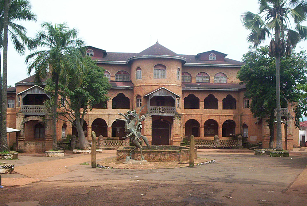
Long before any state claimed this stretch of the Gulf of Guinea coast and the highlands behind it, the land was worked by hunter-gatherer peoples whose descendants survive today as the Baka and Bakola, forest foragers of the south and east whose lineages trace back tens of thousands of years in the Congo Basin, well before anyone spoke a Bantu language here. The grassfields straddling the modern border with Nigeria are widely identified by linguists as the Bantu homeland itself: somewhere between four and five thousand years ago, Bantu-speaking farmers began moving out of this zone southward and eastward across the entire lower half of the continent, one of the largest population movements in African history. What remained in Cameroon was never a single people. By the time organised states appear in the record, the territory held rainforest foragers, savanna farmers, highland chiefdoms, and Sahelian pastoralists, with no single political centre. The first named polities cluster around Lake Chad and the northern savanna. The Sao civilisation rose near the lake around the fifth century CE and flourished from roughly the ninth to the fifteenth century, building fortified settlements and distinctive terracotta art before being absorbed or destroyed by the expanding Kotoko states. Kanem-Bornu, one of the longest-lived dynasties on the continent, controlled the wider Lake Chad basin for close to a thousand years, converting to Islam around the eleventh century and, under Mai Dunama Dabbalemi in the thirteenth century, extending its authority south into the Adamawa grasslands of what is now Cameroon. In the Mandara Mountains a separate kingdom, established around 1500, developed its own tradition of ironworking, terraced hillside farming, and circular stone-walled compounds that still stand. In the early nineteenth century, Fulani pastoralists who had been migrating eastward for generations answered the call of Usman dan Fodio's jihad; under Modibo Adama, Fulani forces conquered much of the north, folding it into the Sokoto Caliphate as the Adamawa Emirate and spreading Islam through conquest and settlement across territory previously governed by smaller non-Muslim chieftaincies. Further south and west, the Bamum kingdom centred on Foumban built one of the more sophisticated precolonial states in the region, ruled from the seventeenth century by the Nchare Yen dynasty and reaching a cultural peak under Sultan Ibrahim Njoya, who took the throne as a child in 1886, survived a civil war in the 1890s, and between 1896 and 1910 invented an entirely original Bamum writing system, evolving it from a five-hundred-symbol pictographic script into an eighty-character syllabary so his people could record their own history in their own language. To the west again, the Bamileke of the grassfields organised themselves not as a single kingdom but as dozens of independent fondoms, each under a fon who combined political, ritual, and land authority, trading foodstuffs, iron goods, and craftwork through dense regional networks. On the coast, the Duala built no empire but something arguably more durable: a set of trading dynasties, the houses of Bell and Akwa foremost among them, who positioned themselves as essential middlemen between European ships and the interior, brokering the exchange of ivory, palm oil, and, without euphemism, enslaved people, both through the Atlantic trade run from the Wouri estuary and through the separate trans-Saharan slave routes that had long carried captives north from the savanna kingdoms toward Kanem-Bornu and beyond. That middleman position gave the Duala kings enough leverage to negotiate terms rather than simply be conquered when Europeans arrived to formalise control. On 12 July 1884, King Ndumbe Lobe Bell and King Akwa signed a protection treaty with agents of the German trading firms Woermann and Jantzen and Thormahlen, ceding sovereignty in exchange for continued trade taxes and property guarantees; the explorer Gustav Nachtigal arrived two days later to formally claim the territory for Germany. German Kamerun quickly became a plantation economy built on forced labour, and by 1910 colonial planners were drawing up schemes to expel the Duala from their own riverfront land to make way for a European-only settlement. Rudolf Duala Manga Bell, grandson of the treaty signatory, organised petitions, legal challenges, and eventually a clandestine appeal to other Cameroonian peoples and foreign governments to resist the expulsion; betrayed to the authorities, he was tried in a rushed, secretive proceeding and hanged for treason on 8 August 1914, days after the outbreak of the First World War in Europe. That war ended German rule within two years, as British and French forces invaded and partitioned the territory between them. The League of Nations formalised the split in 1922 into a larger French Cameroun and a smaller British Cameroons, itself divided into Northern and Southern sections administered from Nigeria. The two colonial powers governed almost oppositely: France pursued direct rule and cultural assimilation, dismantling or subordinating existing chieftaincies to French administrators, while Britain ruled Southern and Northern Cameroons indirectly through existing local authorities as extensions of the Nigerian colonial system, a divergence whose consequences are still argued over today. Cameroonian nationalism found its sharpest edge in the Union des Populations du Cameroun, founded in 1948 under Ruben Um Nyobe, which pushed for immediate independence and reunification of the French and British territories. Banned by the French administration in 1955, the UPC turned to armed insurgency that ran through the late 1950s and, in its later phases, into the 1960s. French and then Cameroonian government forces answered with a counterinsurgency campaign whose brutality is not in serious dispute, though its scale is: colonial-era official figures put total deaths in the single digits, a count long since discredited, while historians working from archival and oral evidence describe tens of thousands killed in the core rebellion years and note that the wider campaign, extended into the postindependence period under President Ahmadou Ahidjo, left a toll that some researchers place far higher still. The exact number remains genuinely contested and is likely to stay that way given how much of the French and Cameroonian documentation was destroyed or withheld. Um Nyobe himself was shot dead by French troops in September 1958. French Cameroun became independent on 1 January 1960 under Ahidjo, with the insurgency still smouldering. In February 1961, a United Nations plebiscite let the people of British Cameroons choose their future: the north voted to join Nigeria, the south voted to join the newly independent Republic of Cameroon. Talks at Foumban that July produced a federal constitution, and on 1 October 1961 the Southern Cameroons entered the union as West Cameroon, forming the Federal Republic of Cameroon alongside Ahidjo's East Cameroon. That federal arrangement lasted just over a decade. A referendum on 20 May 1972 abolished it in favour of a unitary state under a new constitution effective 2 June 1972, a vote Anglophone critics have long argued was neither freely contested nor genuinely representative of Southern Cameroonian opinion, a grievance that would resurface with force decades later. Ahidjo resigned the presidency in November 1982 citing health, handing power to his prime minister, Paul Biya, under the constitutional succession clause. Ahidjo tried to retain control of the ruling party from behind the scenes; the attempt failed, he went into exile, and in 1984 was condemned to death in absentia for an alleged coup plot. Biya has governed continuously since, through a shift to nominal multiparty politics in the early 1990s that left his party dominant. His decades in office now overlap with two live conflicts: a Boko Haram insurgency that has spilled across the Far North from the Lake Chad basin since the mid-2010s, and the Anglophone crisis, which began in 2016 and 2017 as strikes by lawyers and teachers in the Northwest and Southwest protesting the imposition of French-speaking judges and educators on Anglophone institutions, and hardened, after a heavy-handed government crackdown, internet shutdowns, and killings during protests, into an armed separatist movement calling for an independent Ambazonia. That conflict remains unresolved, and for a traveller it is mainly a question of geography: the Northwest and Southwest carry travel warnings, while Douala, Yaounde, the West, the Littoral and the Far North operate normally. The history is unusually easy to visit here, which is what the old nickname about Africa in miniature is actually pointing at. Foumban still has the Bamum royal palace, a working sultanate, and a museum holding Njoya's script alongside the thrones and beaded regalia of the dynasty, and the artisans' quarter along the Rue des Artisans has been casting brass and carving for generations. Bafut's fon's palace, with its thatched Achum shrine, is a living Grassfields court rather than a ruin, and dozens of smaller fondoms across the Bamileke highlands still hold their own. On the coast, Bimbia near Limbe was a departure point for the Atlantic trade and is now a memorial site that returning diaspora have begun to visit in numbers. Douala keeps the German-era buildings, including the Pagoda built for King Bell, and the Doual'art centre for the contemporary side. In the Far North, Rhumsiki and the Kapsiki peaks sit in the Mandara landscape of terraced farming and stone compounds, and the Lamidat at Ngaoundere is the Fulani emirate's surviving seat. A visitor should expect two administrative cultures rather than one: French and English are both official, the legal systems differ between regions for the reasons above, and the switch is real rather than cosmetic. Chieftaincy still carries weight, so entering a palace means asking, and often a small gift; photographing a fon, a sultan, or a ceremony is asked for rather than assumed. The north is largely Muslim and the south largely Christian with strong traditional practice alongside, and both are taken seriously.

What is disputed here: The death toll of the UPC war and the repression that followed has no settled figure and the estimates disagree by roughly a factor of six: a British embassy assessment compiled in 1964 put civilian deaths at sixty to seventy-six thousand between 1956 and 1964, the French general commanding in the Bamileke region put the toll there at twenty thousand for 1960 alone, and a French journalist cited one hundred twenty thousand killed in that region since 1959. No wartime authority kept reliable records, so any single number is a working estimate rather than a fact. The legitimacy of the 1972 referendum that abolished the federation is separately contested on constitutional grounds, since critics argue it required the assent of the Anglophone federated state's own legislature, which was never given, a dispute that still feeds secessionist claims today.

Sources (18) · checked 26 July 2026
  1. 1.Britannica, Cameroon History
  2. 2.Britannica, Ahmadou Ahidjo
  3. 3.Britannica, Paul Biya
  4. 4.Library of Congress, Bamum Script: Sultan Ibrahim Njoya
  5. 5.Wikipedia, Kingdom of Bamum
  6. 6.Wikipedia, Mandara Kingdom
  7. 7.Black Central Europe, Treaty of Protection with Chiefs of Cameroon Coast 1884
  8. 8.Wikipedia, Rudolf Duala Manga Bell
  9. 9.Black Central Europe, Rudolf Duala Manga Bell biography
  10. 10.Wikipedia, 1961 British Cameroons referendum
  11. 11.Wikipedia, West Cameroon
  12. 12.Britannica, Cameroon: Moving toward independence
  13. 13.JusticeInfo.net, Cameroon: Um Nyobe, a hero and symbol of French colonial crimes
  14. 14.Wikipedia, Ruben Um Nyobe
  15. 15.Cambridge Core, Journal of Modern African Studies, Long shadow of the maquis
  16. 16.International Crisis Group, Cameroon's Anglophone Crisis at the Crossroads
  17. 17.USCRI, Timeline: Cameroon and the Anglophone Crisis
  18. 18.Uppsala University DiVA, The Early Bantu Expansion into Central Africa

Peoples of Cameroon

Bamilekealso Bamileke, an umbrella label rather than one people

West Region primarily, extending into Northwest and Southwest; the western highland Grassfields plateau, across roughly a hundred distinct fondoms including Bandjoun, Baham, Bangangte, Dschang, Bafoussam and Batoufam · Ghomala, Yemba, Medumba, Ngombale, Fe'efe'e, Mengaka · roughly 8.4 million by one count, about a fifth of Cameroon, though this figure could not be cross-checked and older sources give far less

Bamileke is not a people so much as a label. It comes from a Bali interpreter's phrase meaning roughly the people down there, which German administrators corrupted into an ethnic category and then applied to about a hundred separate fondoms. People here identify as Bandjoun, Baham, Bangangte or Dschang first, and use Bamileke mainly when speaking to outsiders. Each fondom keeps its own fon, palace and regulatory society, and its own language, related to its neighbours but distinct. What they share is a royal art tradition built around the fon: beaded thrones, hats and elephant masks worn by the Kuosi society at funerals and public feasts, carved ancestor figures, and brasswork. Beadwork is done by women. Coffee farming and long-distance trade have underpinned the economy for a century, and Bamileke trading networks reach into every Cameroonian city.

Visiting: At any fondom palace, greet the fon and his notables formally and wait to be invited to sit. Remove hats and sunglasses at the threshold. Photographing the fon, palace regalia or masked Kuosi members needs permission and sometimes a fee. A small offering of kola nuts or palm wine is expected when asking for an audience. This is general Grassfields courtesy rather than one Bamileke code, because the label covers a hundred separate courts.

Bamounalso Bamum, Bamun, Mum

West Region, Noun Division, centred on Foumban · Shupamum · sources disagree badly, from about 215,000 to around 700,000 speakers

The dynasty was founded in 1394 by Nchare Yen, whose line claims Tikar descent; historians treat that claim as prestige genealogy rather than literal migration. Roughly twenty reigns have followed from Foumban. Sultan Ibrahim Njoya invented a writing system from about 1896, starting with five to six hundred pictographs and refining it by 1910 into an eighty-character syllabary, then used it to compile a pharmacopoeia, a calendar and legal records, and set up schools, a library and a printing press. The palace now holds the Museum of the Bamoun Kings, and the artisans' quarter still casts brass and carves as it has for generations. The Nguon, held every two years in early December, is the striking one: chiefs gather the community's complaints and put the Mfon on public trial over his own governance before restoring him. UNESCO inscribed it in December 2023.

Visiting: Photography is not permitted inside the Sultan's palace museum, which is enforced. Greet royal notables before addressing the Mfon. Guided tours are standard and any photography on the wider grounds should be cleared with the guide. The Nguon comes round only every second year and is tightly ritualised, so go with someone who can say what is open to outsiders and what is not.

Tikaralso Tikari

Bankim, Ngambe Tikar and Magba on the Adamawa and Centre border; several Northwest dynasties claim descent from Tikar migrants · Tikar · roughly 168,000 to 173,000

The Tikar matter out of proportion to their numbers because the Bamum, Nso, Kom and Bafut royal houses all claim descent from them. That claim is oral tradition, and historians are sceptical of a literal mass migration, reading it instead as a prestige genealogy that anchors royal legitimacy across the Grassfields. The linguistic evidence cuts against it too: Tikar is Northern Bantoid, a different branch from the Grassfields languages spoken by the fondoms claiming Tikar descent. The homeland proper around Bankim and Ngambe Tikar keeps its own chieftaincy, wood carving and brasswork independent of the fondoms that cite it. Bedzan forest communities in the Ngambe-Tikar area speak a Tikar-related language, reflecting a long relationship between farming villages and forest foragers in that zone.

Visiting: Documentation specific to Tikar protocol is thin, so general Grassfields and Adamawa courtesy applies. Greet chiefs and elders first and formally, ask before photographing regalia or ceremonies, and dress modestly when entering a chief's compound. Treat this as regional practice rather than a documented Tikar code.

Nsoalso Banso, Lam-nso, Nsaw

Northwest Region, Bui Division, centred on Kumbo and extending into Jakiri · Lamnso · about 411,000 in Cameroon, around 423,000 including Nigeria

The Nso fondom runs from the fon's palace in Kumbo through the Nwerong, also written Ngwerong, the palace regulatory and security society. Nwerong enforces the fon's decisions, is solely responsible for installing a new fon, and oversees replacing the sub-chiefs known as Fai and Shufai. This is worth getting right: Nwerong is Nso's institution, Kwifon belongs to Bafut and Kwifoyn to Kom, and although they do comparable work the names are not interchangeable. The founding figure is Ngonnso, a woman who led her people here after a succession dispute, and the Ngonnso Cultural Festival honours her. A revival was planned for late November 2024 after an eight-year gap, then postponed days beforehand by Nwerong, which said the land needed cleansing and the Nso people needed reconciling over the Anglophone conflict before anyone could celebrate.

Visiting: Address the fon through his notables rather than directly. Remove headwear and greet formally on the palace grounds. Photographing Nwerong members or restricted parts of the palace needs explicit permission and is often refused. Dress conservatively. Check current conditions before travelling, since the Northwest remains unsettled.

Bafutalso Fut, Bufu

Northwest Region, Bafut Subdivision, Mezam Division, near Bamenda · Bafut · over 100,000, with around 134,000 speakers of the language

Bafut traces its origins to Tikar settlers on the Bafut plateau. The palace is a compound of about fifty structures set inside a sacred forest and centred on the Achum shrine, and it is on UNESCO's tentative World Heritage list. Its regulatory society, Kwifon, is unusual in how openly it constrains the ruler: it can question, fine or sanction the fon himself for violating the land's norms, which makes it a formal check on chiefly power rather than simply an enforcement arm. The Abin e Mfor, the Dance of the Fon, is held every December, with notables playing traditional flutes and firing guns, and dancing organised strictly by rank so that princesses, notables and commoners each dance separately. It marks the close of the ritual year. The palace was damaged during the Anglophone conflict.

Visiting: Greet the fon and his notables on entering, and expect to remove footwear or headwear at the threshold. The Achum shrine is off limits to visitors entirely. Photographing Kwifon members or masked ceremonies requires prior permission. Bring a modest gift when requesting an audience, and coordinate access through the palace's own guides rather than assuming general Grassfields norms apply here.

Bakossialso Akosi, Nkosi

Southwest Region, Kupe-Manenguba Division, on the slopes of Mount Kupe and Mount Mwanenguba · Akose · roughly 200,000

Bakossi tradition traces descent from the hunter Ngoe and his wife Sumediang. This is not a Grassfields fondom and should not be described as one: there is no fon, no palace and no kwifon here. Authority sits with village councils and with sacred societies believed to hold protective and regulatory power, with Mwakum recognised as the highest traditional title. Mount Kupe itself was held sacred until relatively recently, and the erosion of that belief is part of why conservation boundaries had to be negotiated with local chiefs to protect what forest remains. Villages divide loosely along mission history, Presbyterian around Nyasoso and Catholic around Bangem, with older ancestral practice persisting alongside both. Farming is the base, coco yam, cassava and corn, with coffee and cocoa as cash crops on the slopes.

Visiting: Greet village elders and title holders first. Ask before photographing sacred society members or ceremonies. Dress modestly when visiting a compound or a shrine. This is general Southwest courtesy, since no Bakossi-specific code is documented, and palace protocol does not apply because there is no palace.

Doualaalso Duala, one people within the wider Sawa coastal umbrella

Littoral Region, Wouri, Moungo and Nkam divisions, centred on the city of Douala · Duala, Bodiman, Oli, Pongo · from roughly 90,000 to 300,000 depending on how narrowly Duala is counted, around 400,000 including Sawa subgroups, and some five million for the coastal Sawa population as a whole

Sawa is the umbrella term for the coastal peoples, and Duala is one of them, historically the most prominent through four centuries of trade with Europeans. Duala society is organised by clan rather than under a single monarch, with the Bell, Akwa, Deido, Priso and Njo lineages each holding their own chieftaincy; the Germans played those rivalries against each other deliberately. The Ngondo is the great annual festival of the Sawa, held over the first two weeks of December on the Wouri, centred on communicating with the ancestors and the water spirits called jengu or miengu. A devotee enters the river and is said to return from the underwater kingdom carrying the ancestors' answer. Canoe races, wrestling and Assiko dancing surround it. UNESCO inscribed it in December 2024.

Visiting: The public days, the races and the dancing, welcome outsiders. The sacred water rite does not: children are excluded and so are the uninitiated. Photography during the ritual segments needs explicit permission from the organisers. Dress and behave modestly on the riverbank ceremonial ground.

Bassaalso Basaa, Bassa'a

Centre Region, Nyong-et-Kelle, and Littoral Region, Sanaga-Maritime and Nkam, around Edea and Eseka · Basaa · about 300,000 language speakers against a broader ethnic estimate near 800,000, a genuine gap rather than a resolved figure

Bassa organisation runs through clan lineage traced to a common ancestor, Mban, dispersing from a founding settlement at Ngog Lituba. Oral tradition explains the name itself from a quarrel among Mban's sons over sharing game after a hunt, from nsa, meaning sharing. There is no fon and no unified chieftaincy here; authority is clan-based. The Bassa belong to the wider Sawa coastal world and take part in the Ngondo alongside the Duala, Bakoko and Bakweri, and are counted among the founding clans of that complex rather than late guests, though a minority tradition traces Ngondo's origins to Bassa rather than Duala history. The region was the centre of radical anticolonial nationalism through the UPC and Ruben Um Nyobe, which remains central to how people here understand themselves.

Visiting: No Bassa-specific code is documented. General coastal Sawa courtesy applies: modest dress, permission before photographing participants, and respect for the restricted rites inside the Ngondo. The UPC history is living politics rather than settled history, so listen rather than offer views.

Bakwerialso Kwe; the language is Mokwe

Southwest Region, Fako Division, over a hundred villages on the eastern and southeastern slopes of Mount Cameroon, with Buea as the main town · Mokwe · figures range from 32,200, a 1982 count of Mokwe speakers, to around 500,000 for people identifying as Bakweri today; the gap is speakers against ethnicity rather than a contradiction

Each village is headed by its own chief and council, a decentralised arrangement rather than one paramount monarchy, though a Bakweri paramount chieftaincy does exist and recent scholarship questions how indigenous it actually is. Succession passes father to son, but a successor must first kill two large pigs and distribute the meat among notables and households before he is recognised, and until then he cannot leave the former chief's village. Bakweri cosmology centres on Liengu la Mwanja, a mermaid-like water spirit among the wider jengu spirits of the coast, said to be consort to Efasa-Moto, the spirit of Mount Cameroon, the two dividing dominion between sea and mountain. The Liengu rites belong to the most active women's society here, alongside Maale, Mbwaya and Nganya. The named public festival is Mbando, revived by the Buea and Limbe paramount rulers in 2022.

Visiting: Greet the village chief and council on arrival, particularly before any cultural event. Liengu observances and succession rites are not public spectacle and should not be photographed without explicit permission. Dress modestly near the mountain's sacred sites. There is no Bakweri mermaid festival despite what some listings claim; the mermaid material belongs to a women's society, and Mbando is the actual public event.

Fulanialso Fulbe, Peul, Fula; the pastoralist subgroup is Mbororo

Adamawa, North and Far North Regions, historically centred on Ngaoundere and Garoua · Adamawa Fulfulde · roughly three to four million, the range depending on whether Mbororo and other Fulbe subgroups are counted separately

The lamido is the traditional ruler of a lamidat, at once political administrator, judge and Islamic spiritual leader, and the lamidats at Ngaoundere and Maroua still function, hosting Eid celebrations and turbaning ceremonies. The Adamawa Emirate was founded through a nineteenth-century jihad under Modibo Adama, whose subordinates established Ngaoundere, Tibati and the rest. A real distinction runs through the community between settled, urban Fulbe and the nomadic Mbororo cattle-herders, whose name comes from a Fulfulde word for cattle; across the twentieth century the movement has been steadily from nomadic toward settled. Conduct is governed by Pulaaku, a code of patience, dignity, modesty and self-restraint, visible in dress: men in a boubou with a pointed noppire hat, women in a lepi wrap with colourful headscarves and heavy gold earrings.

Visiting: Dress modestly, especially near a lamidat or a grand mosque. Greet elders first and without hurrying. Use the right hand only for giving and receiving. Many people will not shake hands across genders, so wait rather than offer. Do not bring alcohol as a gift. Women visitors should carry a scarf, though norms relax somewhat in the northern tourist towns.

Kirdialso a colonial exonym, not a self-identification, covering Toupouri, Massa, Moundang, Guiziga, Mafa, Mofou, Mousgoum, Fali, Kapsiki and dozens more

North and Far North Regions, in the mountain and plains refuges of the Mandara range and the Diamare plain · Mafa, Kapsiki, Toupouri, Mousgoum, Guiziga, Massa, Moundang · no meaningful single figure exists, because Kirdi is not a self-identified or separately counted category; the number of groups placed under it ranges from about 26 to over 40 depending on the source

Kirdi has to be understood as a label rather than a people. Sources disagree on whether it comes through Kanuri from Arabic, from Choa Arabic, or through Fulfulde, but they agree on the meaning: pagan, or infidel, applied by Fulani conquerors during the nineteenth-century jihad to the many non-Muslim peoples of the Far North who refused conversion. Those peoples, the Toupouri, Massa, Moundang, Guiziga, Mafa, Mofou, Fali, Mousgoum and dozens more, are linguistically and culturally unrelated to each other. What they share is having retreated into hills and mountains to escape Fulani rule, and having been grouped afterwards under a single dismissive word by the people they escaped from. A modern political identity movement has reclaimed the term, but for a traveller it works best as a heading that explains the history and then points to the individual peoples.

Visiting: There is no Kirdi etiquette because there is no Kirdi people. Behave according to whichever community you are actually visiting, Mafa or Kapsiki or Toupouri, rather than treating the label as a culture. Using the word to someone's face is a choice worth thinking about, given where it came from.

Mafa and Kapsikialso Mafa is natively Mofa, historically called Matakam; Kapsiki is Kamwe in Nigeria and the language is Psikye

the Mandara Mountains, Far North Region; Mafa on the Mokolo plateau, Kapsiki centred on Rhumsiki, Sir and Ourya · Mafa, Psikye · Mafa from about 365,000 to over a million depending on source, an unresolved gap; Kapsiki around 133,000 to 161,000

Both peoples farm terraced mountainsides held by stone bunds, which is what lets an otherwise marginal landscape carry a dense population; the terraces come with crop rotation, mixed cropping and agroforestry, and the wider landscape of homes, tombs, worship sites and artisan quarters is recognised by UNESCO as the Diy-Gid-Biy cultural landscape. Among the Mafa, an endogamous blacksmith group, the ngwazla, is distinguished from the farming majority. Kapsiki keep a divination practice in which a diviner reads outcomes from how a crab moves small wooden markers, performed in dedicated spaces inside compounds. Both are grouped as Kirdi precisely because they resisted Islamisation, which means their leadership is a non-Islamic chieftaincy rather than a lamidat.

Visiting: Walks around Rhumsiki are usually guided by village association guides, circling the peak through compounds with stone enclosures and granaries and stopping at blacksmiths, potters, weavers and the crab diviner. Hire a registered local guide. Ask before photographing people or ritual spaces, and treat the crab divination as a practice rather than an attraction, since no photography or fee policy is documented for it.

Hausaalso Hausa

no single Cameroonian homeland; a trading diaspora across the country, originating in Hausaland on the Niger and Nigeria border, arriving from the late nineteenth century · Hausa · about 453,000, from a single source that could not be cross-checked

Long-distance merchants by tradition, trading ivory and kola nuts north across the Sahel, Hausa traders in German Cameroon were recruited as guides and intelligence sources and some served in colonial military campaigns. The community is overwhelmingly Sunni Muslim. Hausa in Cameroon are an extension of a shared Hausaland identity rather than a separate origin, and the language is the most widely spoken of the whole Chadic branch, which makes it useful far beyond the community itself. In Cameroonian towns Hausa traders have historically clustered in their own quarters, though specific named quarters were not confirmed in the sourcing available.

Visiting: The same courtesies as for Fulani hosts apply: modest dress, right hand only for giving and receiving, no alcohol as a gift, and gender-sensitive greeting. Wait to see whether a hand is offered rather than extending yours first. No Hausa-specific code distinct from general Muslim Cameroonian practice is documented.

Beti-Pahuinalso Beti, Ekang; subgroups include Ewondo, Eton and Bulu

Ewondo around Yaounde and the Mfoundi; Eton immediately north of Yaounde; Bulu in the South Region around Ebolowa and Sangmelima · Ewondo, Eton, Bulu · Ewondo and Beti around 2.35 million, Bulu from 660,000 to over 800,000, the whole cluster well above five million, none of these figures reconciled with each other

Beti society is organised into named clans that govern identity and enforce marriage outside one's own clan. The mvet, a harp-zither amplified with calabashes, is played by storytellers through all-night performances that mix mythological narrative with sung commentary on real disputes in the community. Bikutsi, meaning beat the earth in Ewondo, is traditionally a women's music and dance form performed with balafon and body percussion, its lyrics dealing openly with sexuality, relationships and social tension; Anne-Marie Nzie, performing from the 1940s, is its acknowledged queen. Ewondo cosmology names evu, a malevolent spiritual agency paired with awu, death, both said to have entered the world through an ancestral act of disobedience. The Beti are the indigenous community of the capital, and President Biya is Bulu, which shapes how power is read in Yaounde.

Visiting: No Beti-specific code is documented beyond general Cameroonian courtesy: greet elders first and without rushing the exchange, and use the right hand for giving and receiving. Politics around ethnicity and appointments is discussed constantly in Yaounde and is not a subject on which a visitor's opinion is wanted.

Bakaalso distinct from the related Bagyeli and Bakola, who should not be conflated with them

southeastern East Region, Boumba-et-Ngoko, Kadey and Upper Nyong, and South Region including the Dja Faunal Reserve · Baka · from 25,000 to 75,000 depending on definition and year

Semi-nomadic forest people, the Baka treat the forest as the source of shelter, medicine and food. The forest spirit Jengi, also Edjengi or Ejengi, mediates between them and the supreme being Komba and is described as a protecting, father-like guardian. Men are initiated into adulthood through Jengi rites, after which they may move freely in the sacred forest, and a successful hunt is honoured with the thanksgiving song and dance called Luma. Hunting uses raffia-cable traps, concealed pits and trained dogs; gathering is deliberately conservative, with controlled smoke for honey and wild yams replanted after harvest. Baka polyphonic singing is musicologically remarkable, though the UNESCO listing for Pygmy polyphony belongs to the Aka of the Central African Republic, a different people. Cameroonian law does not recognise customary or collective land rights, which leaves Baka communities exposed to displacement by logging, mining and conservation enforcement alike. Their language is a linguistic outlier among Bantu and Ubangian neighbours, and roughly a third of its vocabulary, mostly forest terms for plants, honey and medicine, is thought to survive from an older ancestral language.

Visiting: This is thinly documented and the rights context is live, so err heavily toward restraint. Get explicit consent for any photography of people or ceremonies. Do not pay for a staged Jengi ritual, which is genuinely restricted. Prefer visits arranged through the community's own associations over unaffiliated operators, and treat a forest walk as someone's home rather than an attraction.

Every other people recorded in Cameroon (266)

Listed rather than written up. Naming a people is not the same as explaining them, and we would rather show the full range than pretend the written entries above are all of it.

  • Bate (Bata)Far North Region · Chadic, Afro-Asiatic
  • BuwalFar North Region · Chadic, Afro-Asiatic
  • CuvokFar North Region · Chadic, Afro-Asiatic
  • DabaFar North Region · Chadic, Afro-Asiatic
  • DghwedeFar North Region · Chadic, Afro-Asiatic
  • Dugun (Saa)Far North Region · Chadic, Afro-Asiatic
  • DugworFar North Region · Chadic, Afro-Asiatic
  • Fali (Bana)Far North Region · Chadic, Afro-Asiatic
  • Fali of JibuFar North Region · Chadic, Afro-Asiatic
  • Fali NorthFar North Region · Chadic, Afro-Asiatic
  • Fali SouthFar North Region · Chadic, Afro-Asiatic
  • GavarFar North Region · Chadic, Afro-Asiatic
  • GidarFar North Region · Chadic, Afro-Asiatic
  • Giziga NorthFar North Region · Chadic, Afro-Asiatic
  • Giziga SouthFar North Region · Chadic, Afro-Asiatic
  • GlavdaFar North Region · Chadic, Afro-Asiatic
  • Gude (Cheke)Far North Region · Chadic, Afro-Asiatic
  • GudufFar North Region · Chadic, Afro-Asiatic
  • Hide (Hdi)Far North Region · Chadic, Afro-Asiatic
  • HijukFar North Region · Chadic, Afro-Asiatic
  • Hina (Mina)Far North Region · Chadic, Afro-Asiatic
  • HyaFar North Region · Chadic, Afro-Asiatic
  • Kamwe (Higi)Far North Region · Chadic, Afro-Asiatic
  • KeraFar North Region · Chadic, Afro-Asiatic
  • Kotoko-AfadeFar North Region · Chadic, Afro-Asiatic
  • Kotoko-LagwanFar North Region · Chadic, Afro-Asiatic
  • Kotoko-MalgbeFar North Region · Chadic, Afro-Asiatic
  • Kotoko-MaslamFar North Region · Chadic, Afro-Asiatic
  • Kotoko-MpadeFar North Region · Chadic, Afro-Asiatic
  • Kotoko-MserFar North Region · Chadic, Afro-Asiatic
  • LefaFar North Region · Chadic, Afro-Asiatic
  • MadaFar North Region · Chadic, Afro-Asiatic
  • MajeraFar North Region · Chadic, Afro-Asiatic
  • Mandara (Wandala)Far North Region · Chadic, Afro-Asiatic
  • Masa (Masana)Far North Region · Chadic, Afro-Asiatic
  • Matal (Muktile)Far North Region · Chadic, Afro-Asiatic
  • MazagwayFar North Region · Chadic, Afro-Asiatic
  • Mbedam (Mbudum)Far North Region · Chadic, Afro-Asiatic
  • Mboku (Mbuko)Far North Region · Chadic, Afro-Asiatic
  • MefeleFar North Region · Chadic, Afro-Asiatic
  • MereyFar North Region · Chadic, Afro-Asiatic
  • Mofu NorthFar North Region · Chadic, Afro-Asiatic
  • Mofu South (Mofu-Gudur)Far North Region · Chadic, Afro-Asiatic
  • MolokoFar North Region · Chadic, Afro-Asiatic
  • MuyangFar North Region · Chadic, Afro-Asiatic
  • Vame (Ndreme-Pelasla)Far North Region · Chadic, Afro-Asiatic
  • Gvoko (Ngoshe Sama)Far North Region · Chadic, Afro-Asiatic
  • Peve (Lame)Far North Region · Chadic, Afro-Asiatic
  • Podoko (Parkwa)Far North Region · Chadic, Afro-Asiatic
  • SharwaFar North Region · Chadic, Afro-Asiatic
  • So (Fo, Swo)Far North Region · Chadic, Afro-Asiatic
  • Vemgo-MabasFar North Region · Chadic, Afro-Asiatic
  • Wuzlam (Uzam)Far North Region · Chadic, Afro-Asiatic
  • Zulgo-GemzekFar North Region · Chadic, Afro-Asiatic
  • OuldemeFar North Region · Chadic, Afro-Asiatic
  • FataFar North Region · Chadic, Afro-Asiatic
  • HurzaFar North Region · Chadic, Afro-Asiatic
  • Baggara (Shuwa Arab)Far North Region · Semitic (Chadian Arabic), Afro-Asiatic
  • Kanuri (Yerwa)Far North Region · Saharan, Nilo-Saharan
  • BudumaFar North Region · Saharan, Nilo-Saharan
  • Sara MbaiFar North Region · Central Sudanic, Nilo-Saharan
  • NgambayFar North Region · Central Sudanic, Nilo-Saharan
  • Fulani, NigerianNorth Region · Atlantic, Niger-Congo
  • Fulbe-GeyNorth Region · Atlantic, Niger-Congo
  • Chamba DakaNorth Region · Adamawa, Niger-Congo
  • Chamba LekoNorth Region · Adamawa, Niger-Congo
  • Doyayo (Namshi)North Region · Adamawa, Niger-Congo
  • DuupaNorth Region · Adamawa, Niger-Congo
  • Gimme (Kompara)North Region · Adamawa, Niger-Congo
  • Gimnime (Kadam)North Region · Adamawa, Niger-Congo
  • Jimi (Jimjimen)North Region · Adamawa, Niger-Congo
  • Kolbila (Kolena)North Region · Adamawa, Niger-Congo
  • KomaNorth Region · Adamawa, Niger-Congo
  • Mangbai (Mambai)North Region · Adamawa, Niger-Congo
  • Mubako (Mumbake)North Region · Adamawa, Niger-Congo
  • MumuyeNorth Region · Adamawa, Niger-Congo
  • Mundang (Lere)North Region · Adamawa, Niger-Congo
  • NdoolaNorth Region · Adamawa, Niger-Congo
  • PeereNorth Region · Adamawa, Niger-Congo
  • TupuriNorth Region · Adamawa, Niger-Congo
  • VerreNorth Region · Adamawa, Niger-Congo
  • Mbum (Wuna)Adamawa Region · Adamawa, Niger-Congo
  • Dii (Yag Dii)Adamawa Region · Adamawa, Niger-Congo
  • Karang-PandamaAdamawa Region · Adamawa, Niger-Congo
  • Kamkam (Mbongno)Adamawa Region · Adamawa, Niger-Congo
  • Konja (Kwanji)Adamawa Region · Adamawa, Niger-Congo
  • KuoAdamawa Region · Adamawa, Niger-Congo
  • Nimbari (Nyamnyam)Adamawa Region · Adamawa, Niger-Congo
  • NizaaAdamawa Region · Adamawa, Niger-Congo
  • PanaAdamawa Region · Adamawa, Niger-Congo
  • TwendiAdamawa Region · Adamawa, Niger-Congo
  • WawaAdamawa Region · Adamawa, Niger-Congo
  • Woko (Longto)Adamawa Region · Adamawa, Niger-Congo
  • Djanti (Tibea)Adamawa Region · Adamawa, Niger-Congo
  • Bebe (Naami)Adamawa Region · Adamawa, Niger-Congo
  • Gbaya NorthwestAdamawa Region · Ubangian, Niger-Congo
  • Gbaya-MumAdamawa Region · Ubangian, Niger-Congo
  • KareAdamawa Region · Ubangian, Niger-Congo
  • Manja (Mandja)Adamawa Region · Ubangian, Niger-Congo
  • NzakmbayAdamawa Region · Ubangian, Niger-Congo
  • MambilaAdamawa Region · Mambiloid, Bantoid, Niger-Congo
  • VuteAdamawa Region · Mbam Bantu, Niger-Congo
  • Aghem (Wum)Northwest Region · Grassfields Bantoid, Niger-Congo
  • AkumNorthwest Region · Grassfields Bantoid, Niger-Congo
  • Amasi-Banta (Manta)Northwest Region · Grassfields Bantoid, Niger-Congo
  • AmbeleNorthwest Region · Grassfields Bantoid, Niger-Congo
  • AtongNorthwest Region · Grassfields Bantoid, Niger-Congo
  • AwingNorthwest Region · Grassfields Bantoid, Niger-Congo
  • BabaNorthwest Region · Grassfields Bantoid, Niger-Congo
  • BabankiNorthwest Region · Grassfields Bantoid, Niger-Congo
  • BafanjiNorthwest Region · Grassfields Bantoid, Niger-Congo
  • Bafumen (Mmen)Northwest Region · Grassfields Bantoid, Niger-Congo
  • Bali (Mungaka, Bali Nyonga)Northwest Region · Grassfields Bantoid, Niger-Congo
  • BaloNorthwest Region · Grassfields Bantoid, Niger-Congo
  • BamaliNorthwest Region · Grassfields Bantoid, Niger-Congo
  • BambalangNorthwest Region · Grassfields Bantoid, Niger-Congo
  • BambiliNorthwest Region · Grassfields Bantoid, Niger-Congo
  • BamukumbitNorthwest Region · Grassfields Bantoid, Niger-Congo
  • Mesaka (Banagere-Iyon)Northwest Region · Grassfields Bantoid, Niger-Congo
  • BangolanNorthwest Region · Grassfields Bantoid, Niger-Congo
  • BatiNorthwest Region · Grassfields Bantoid, Niger-Congo
  • BebaNorthwest Region · Grassfields Bantoid, Niger-Congo
  • Belip (Nulibie)Northwest Region · Grassfields Bantoid, Niger-Congo
  • Benyi (Numala)Northwest Region · Grassfields Bantoid, Niger-Congo
  • Biba-BefangNorthwest Region · Grassfields Bantoid, Niger-Congo
  • BumNorthwest Region · Grassfields Bantoid, Niger-Congo
  • BusamNorthwest Region · Grassfields Bantoid, Niger-Congo
  • Buu (Mundabli)Northwest Region · Grassfields Bantoid, Niger-Congo
  • ChungNorthwest Region · Grassfields Bantoid, Niger-Congo
  • DekNorthwest Region · Grassfields Bantoid, Niger-Congo
  • Mbule (Dumbule)Northwest Region · Grassfields Bantoid, Niger-Congo
  • DzodinkaNorthwest Region · Grassfields Bantoid, Niger-Congo
  • EsimbiNorthwest Region · Grassfields Bantoid, Niger-Congo
  • IsuNorthwest Region · Grassfields Bantoid, Niger-Congo
  • Limbum (Wimbum)Northwest Region · Grassfields Bantoid, Niger-Congo
  • KoshinNorthwest Region · Grassfields Bantoid, Niger-Congo
  • KukNorthwest Region · Grassfields Bantoid, Niger-Congo
  • KemedzungNorthwest Region · Grassfields Bantoid, Niger-Congo
  • KungNorthwest Region · Grassfields Bantoid, Niger-Congo
  • KwajaNorthwest Region · Grassfields Bantoid, Niger-Congo
  • LaimbueNorthwest Region · Grassfields Bantoid, Niger-Congo
  • Mandankwe-NkwenNorthwest Region · Grassfields Bantoid, Niger-Congo
  • MbawNorthwest Region · Grassfields Bantoid, Niger-Congo
  • MbessaNorthwest Region · Grassfields Bantoid, Niger-Congo
  • Ajumbu (Mbu)Northwest Region · Grassfields Bantoid, Niger-Congo
  • MbukNorthwest Region · Grassfields Bantoid, Niger-Congo
  • Naki (Mekaf)Northwest Region · Grassfields Bantoid, Niger-Congo
  • MenkaNorthwest Region · Grassfields Bantoid, Niger-Congo
  • Mungbam (Mijong-Missong)Northwest Region · Grassfields Bantoid, Niger-Congo
  • MonoNorthwest Region · Grassfields Bantoid, Niger-Congo
  • NchaneNorthwest Region · Grassfields Bantoid, Niger-Congo
  • NdemliNorthwest Region · Grassfields Bantoid, Niger-Congo
  • MfumteNorthwest Region · Grassfields Bantoid, Niger-Congo
  • Moghamo (Ngamambo)Northwest Region · Grassfields Bantoid, Niger-Congo
  • NgembaNorthwest Region · Grassfields Bantoid, Niger-Congo
  • NgieNorthwest Region · Grassfields Bantoid, Niger-Congo
  • NgoshieNorthwest Region · Grassfields Bantoid, Niger-Congo
  • Vengo (Babungo)Northwest Region · Grassfields Bantoid, Niger-Congo
  • NgwoNorthwest Region · Grassfields Bantoid, Niger-Congo
  • NjenNorthwest Region · Grassfields Bantoid, Niger-Congo
  • NjikumNorthwest Region · Grassfields Bantoid, Niger-Congo
  • KomNorthwest Region · Grassfields Bantoid, Niger-Congo
  • NkonghoNorthwest Region · Grassfields Bantoid, Niger-Congo
  • NoniNorthwest Region · Grassfields Bantoid, Niger-Congo
  • Nsari (Akweto)Northwest Region · Grassfields Bantoid, Niger-Congo
  • Nzanyi (Jeng)Northwest Region · Grassfields Bantoid, Niger-Congo
  • OkuNorthwest Region · Grassfields Bantoid, Niger-Congo
  • OsatuNorthwest Region · Grassfields Bantoid, Niger-Congo
  • PinyinNorthwest Region · Grassfields Bantoid, Niger-Congo
  • Tigon (Mbembe)Northwest Region · Grassfields Bantoid, Niger-Congo
  • WehNorthwest Region · Grassfields Bantoid, Niger-Congo
  • MetaNorthwest Region · Grassfields Bantoid, Niger-Congo
  • WomNorthwest Region · Grassfields Bantoid, Niger-Congo
  • Wushi (Babessi)Northwest Region · Grassfields Bantoid, Niger-Congo
  • YambaNorthwest Region · Grassfields Bantoid, Niger-Congo
  • ZhoaNorthwest Region · Grassfields Bantoid, Niger-Congo
  • Kenswei Nsei (Ndop-Bamessing)Northwest Region · Grassfields Bantoid, Niger-Congo
  • Muka (Ndop-Bamunka)Northwest Region · Grassfields Bantoid, Niger-Congo
  • MundaniNorthwest Region · Grassfields Bantoid, Niger-Congo
  • Bamileke-BakwaWest Region · Grassfields Bantoid, Niger-Congo
  • Bamileke-BamenjouWest Region · Grassfields Bantoid, Niger-Congo
  • Bamileke-Bandjoun (Ghomala)West Region · Grassfields Bantoid, Niger-Congo
  • Bamileke-BatchamWest Region · Grassfields Bantoid, Niger-Congo
  • Bamileke-Fefe (Bafang)West Region · Grassfields Bantoid, Niger-Congo
  • Bamileke-Medumba (Bangangte)West Region · Grassfields Bantoid, Niger-Congo
  • Bamileke-NdandaWest Region · Grassfields Bantoid, Niger-Congo
  • Bamileke-Ngombale (Babadjou)West Region · Grassfields Bantoid, Niger-Congo
  • Bamileke-Tchang (Dschang-Yemba)West Region · Grassfields Bantoid, Niger-Congo
  • Mengaka (Ghap)West Region · Grassfields Bantoid, Niger-Congo
  • Bamenyam (Bagam)West Region · Grassfields Bantoid, Niger-Congo
  • NgombaWest Region · Grassfields Bantoid, Niger-Congo
  • Abo (Bankon)Littoral Region · Sawabantu, Niger-Congo
  • Bakoko (Basoo)Littoral Region · Sawabantu, Niger-Congo
  • Mbonga (Mboa)Littoral Region · Sawabantu, Niger-Congo
  • Mulimba (Limba)Littoral Region · Sawabantu, Niger-Congo
  • BakakaLittoral Region · Bantu, Niger-Congo
  • BonkengLittoral Region · Bantu, Niger-Congo
  • DimbongLittoral Region · Bantu, Niger-Congo
  • Nen (Banen, Tunen)Littoral Region · Mbam Bantu, Niger-Congo
  • Bakole (Bamusso)Southwest Region · Sawabantu, Niger-Congo
  • Kundu (Bakundu)Southwest Region · Sawabantu, Niger-Congo
  • Su (Isubu)Southwest Region · Sawabantu, Niger-Congo
  • WoveaSouthwest Region · Sawabantu, Niger-Congo
  • Barombi (Lambi)Southwest Region · Manenguba Bantu, Niger-Congo
  • Bassossi (Sosi)Southwest Region · Manenguba Bantu, Niger-Congo
  • Mbo (Manenguba)Southwest Region · Manenguba Bantu, Niger-Congo
  • Bobe (Bubia)Southwest Region · Bantu, Niger-Congo
  • KendemSouthwest Region · Bantu, Niger-Congo
  • Bomboko (Wumboko)Southwest Region · Bantu, Niger-Congo
  • EfaiSouthwest Region · Bantu, Niger-Congo
  • EmanSouthwest Region · Bantu, Niger-Congo
  • EvantSouthwest Region · Bantu, Niger-Congo
  • Ipulo (Assumbo)Southwest Region · Bantu, Niger-Congo
  • IyiveSouthwest Region · Bantu, Niger-Congo
  • Kenyang (Nyang-Manyang)Southwest Region · Bantu, Niger-Congo
  • Obang ValleySouthwest Region · Bantu, Niger-Congo
  • UsakadeSouthwest Region · Bantu, Niger-Congo
  • BitareSouthwest Region · Bantu, Niger-Congo
  • Denya (Anyang)Southwest Region · Ekoid Bantu, Niger-Congo
  • Ejagham (Ekoi)Southwest Region · Ekoid Bantu, Niger-Congo
  • Iceve-Maci (Becheve)Southwest Region · Ekoid Bantu, Niger-Congo
  • Efik (Calabari)Southwest Region · Cross River, Niger-Congo
  • IbibioSouthwest Region · Cross River, Niger-Congo
  • Korop (Ododop)Southwest Region · Cross River, Niger-Congo
  • AkunakunaSouthwest Region · Cross River, Niger-Congo
  • KutebSouthwest Region · Jukunoid, Niger-Congo
  • YukubenSouthwest Region · Jukunoid, Niger-Congo
  • TivSouthwest Region · Tivoid, Bantoid, Niger-Congo
  • Ngwe (Bangwa)Southwest Region · Grassfields Bantoid, Niger-Congo
  • MmuockSouthwest Region · Grassfields Bantoid, Niger-Congo
  • Bafia (Bekpak)Centre Region · Mbam Bantu, Niger-Congo
  • Tuki (Betsinga-Sanaga)Centre Region · Mbam Bantu, Niger-Congo
  • NomaandeCentre Region · Mbam Bantu, Niger-Congo
  • NyokonCentre Region · Mbam Bantu, Niger-Congo
  • Yambasa (Nu Gunu)Centre Region · Mbam Bantu, Niger-Congo
  • MengisaCentre Region · Bantu, Niger-Congo
  • MpumpongCentre Region · Bantu, Niger-Congo
  • TuotombCentre Region · Bantu, Niger-Congo
  • Yambetta (Nedek)Centre Region · Bantu, Niger-Congo
  • YangbenCentre Region · Bantu, Niger-Congo
  • BedzanCentre Region · Bantoid, Niger-Congo
  • Bagyele (Gyeli)South Region · Bantu, Niger-Congo
  • BatangaSouth Region · Bantu, Niger-Congo
  • Fang-BenjubeSouth Region · Bantu, Niger-Congo
  • Fang-NtumSouth Region · Bantu, Niger-Congo
  • Ngumba (Kwasio)South Region · Bantu, Niger-Congo
  • Yasa (Iyasa)South Region · Bantu, Niger-Congo
  • Badwe'e (Koonzime)East Region · Bantu, Niger-Congo
  • Bakoum (Kwakum)East Region · Bantu, Niger-Congo
  • BakweleEast Region · Bantu, Niger-Congo
  • BanganduEast Region · Bantu, Niger-Congo
  • Nubaca (Bango)East Region · Bantu, Niger-Congo
  • BebeleEast Region · Bantu, Niger-Congo
  • BebilEast Region · Bantu, Niger-Congo
  • Kol (Bikele-Bikay)East Region · Bantu, Niger-Congo
  • BomwaliEast Region · Bantu, Niger-Congo
  • CakaEast Region · Bantu, Niger-Congo
  • KakoEast Region · Bantu, Niger-Congo
  • Makaa NorthEast Region · Bantu, Niger-Congo
  • Makaa SouthEast Region · Bantu, Niger-Congo
  • Mpiemo (Mbimu)East Region · Bantu, Niger-Congo
  • NjyemEast Region · Bantu, Niger-Congo
  • NzimeEast Region · Bantu, Niger-Congo
  • Gbaya-MbadomoEast Region · Ubangian, Niger-Congo
  • Pol (Congo Pol)East Region · Ubangian, Niger-Congo
  • SangoEast Region · Ubangian, Niger-Congo

Written by people from here

The short history above is a summary assembled from published sources. What follows was written by people with a direct connection to Cameroon, in their own words, and reviewed before publication.

Nobody has written about Cameroon here yet. If your family is from here, or you carry a history that the summaries keep flattening, this is the space for it.

Write the first piece
Does this match what you know?
Chat with us on WhatsApp